How to Integrate Google Maps in SAP Fiori Apps
Category: SAP FIORI & UI5 Posted:Jun 20, 2018 By: Ashley Morrison
 SAP UI5 application can be powered by Google Maps with regard to logistics support as it offers optimized routes for any transport along with live traffic updates traveling time detailed information about the route and detailed information about the route and toll roads and a lot more.
Even though map services are offered by several companies and in turn can be implemented in UI5 applications, Google Maps is probably the best product to use for integration with SAP UI5.
In order to integrate Google Maps with SAP UI5 application you require Google Map API. Furthermore, there are various API available in the market for Google Maps such as Google maps for street, Google map for iOS, Google Map Android API, Google Maps directions API and a whole lot more. There is also Google Maps JavaScript API.
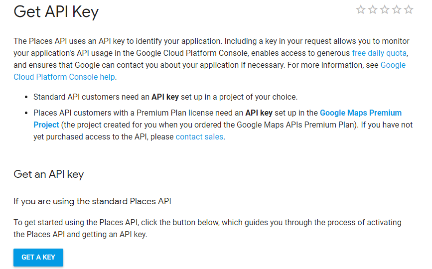
In order to make use Google API you will require a specific developer API key given below are the steps required to create a developer key and use the API in the particular application:
- Go to the Google Developers Console.
- Create or select a project.
- Click Continue to enable the API and any related services.
- On the Credentials page, get a Browser key (and set the API Credentials)
- Example
Steps to create the application:
- Open the SAP WEB IDE from Services.
- Choose File -> NEW -> Project From Template -> SAPUI5 Application.
- Provide the basic information (Project Name and Name Space) to the application.
- Select the View Type (HTML, XML, JSON, JavaScript) as HTML (using in our application).
SAP UI5 is considered a standard and open source technology, which is supported with JavaScript API which is also a standard open source technology used by Enterprises the world over
You require an HTML page to post a Google map in a container element. This can be used to display the Google map. This container element is a DIV tag and is utilized to embed the Google map.
The next step is to create Google Maps API. This will have certain property such as a center parameter a control object and the zoom level. The center parameter is the location where it needs to be placed on the container element. The Google Maps API will then send the map and display it on the container object which is actually a DIV tag
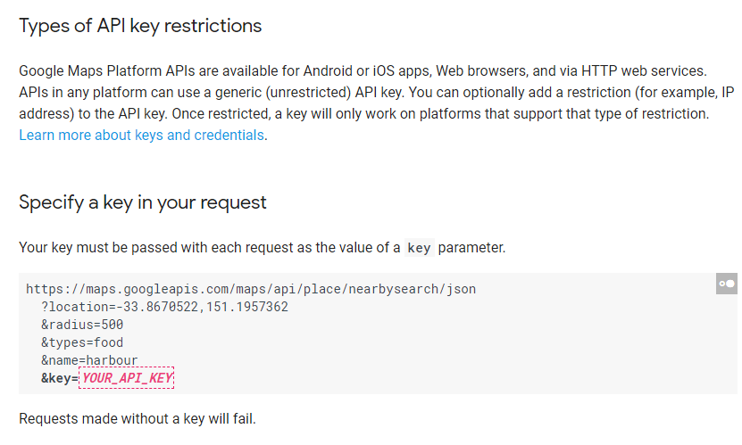
In order to trace a location on the map we utilize latitude and longitude properties or coordinates. To make use of Google Maps you need to load Google API bootstrap which in which will invoke the Google engine. This can be accomplished using a custom control in the SAP UI5 SDK as there is no direct control to map integration within SAP UI5. In order to invoke Google Maps you require the KEY from Google. The key is not free for functional uses word for developers Google offers temporary KEY which can be utilized to integrate maps into Fiori applications. Given below is an example of Google Maps integrated with SAP Application.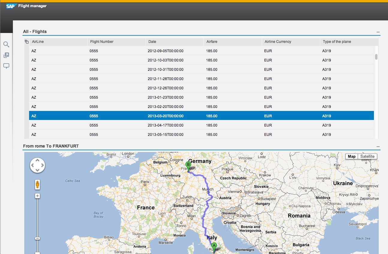
Yet another PPI, which is offered by Google is Geocoder API which helps in searching for a location on integrated Google Maps on the Fiori application. Once again and it is necessary to provide the search feature.
Another API is called marker API which is used to highlight specific geographical location using a red mark. Once Google Map is displayed when you search for location it will be highlighted with red marker. User icon will also be displayed which can be dragged and the location photos can be displayed on the map as well.
The SAP entity SAP AG in collaboration with Google is aiding its customers in the management of massive data volumes with regard to visual displays with intuitive and faster facilitation leading to well informed decisions as never thought before. SAP also has plans to improve its business analytics solution suite by enhancing it with location based data capabilities. This in turn will help people to interact and execute based on real time data through Google Maps. SAP and Google have known to collaborate on various technological advances, the most recent of which was the Google maps application which made use of the Google app Marketplace integration with open source adoption and Google docs.
Google and SAP are coordinating to bring about enterprise applications which can benefit consumers with tools that enhance everyday lives. This is based on pairing technologies from both Enterprises to come up with hybrid applications which make use of features from both companies. Google maps and Google Earth are the first contenders for such an effort with Google Maps taking the lead.
SAP envisions platform where it can bring corporate information and data to life using Google’s interactive and dynamic map and satellite applications, this also includes Google Street View which is used by customers from every strata of society. Using these consumers can analyze enterprises against the Geo spatial context in order to optimally comprehend their information and where it comes from – both geographic and demographic perspectives. Location will open up other areas of information which will include, but not be limited to regional, global and local trends and how such Trends are influenced by varying scenarios. This should play a greater part in increasing profitability through enhancement of efficiency among other distinct advantages.
SAP operations are known to be driving a merger of sorts for consumer software and enterprise software leading to an increasing number of consumers gaining the ability to take important business decisions powered by social and mobile Technologies. While enterprises have channeled efforts to achieve similar goals, Google stands apart from the crowd by simplifying technology to be accessible to the masses while keeping up with Complex Technologies such as big data and the growing influx of consumer data.
Google Maps is easily the world’s most used online mapping tool with nearly comprehensive Global coverage. When it comes to the perspective of enterprise users in customers Google Maps offers a cost-effective option which can be easily deployed as a mapping platform. What’s more is, this can make it easier to visualize Geographic data with Enterprises large and small using Google’s growing infrastructure to process large amounts, of such as graphic data and gain enhanced insights into their own business.
Given below are examples of how enterprises which run SAP solutions with Google Maps API premier can gain from enterprise information being juxtaposed onto mapping tools that are highly intuitive:
Telecom operators can utilize SAP business objects Explorer software and Google Earth in conjunction to execute drop call analysis and pinpoint the exact location of faulty signal Towers.
Departments of revenue for a state within a country can overlay Tax Information according to households on a state map and draw up statistics accordingly.
A bank that is lending out mortgages could execute a detailed risk assessment of its various mortgage portfolios by overlaying default and foreclosure data using location of loans availed by people according to geographical location.
Using SAP stream work a group of customer support representatives with them a company that manufactures, packaging consumer goods code collaborate and pain. The exact location of consumer issues within particular geography’s and take a call on how to address set issues and prioritize the solution.
To conclude, SAP has once again proven how versatile its products are in terms of flexibility, interoperability, and universal functionality. Hence it won’t come as a surprise that integration with Google maps is relatively simple and provides great scope for increasing app functionality to greater extents.
I hope that by now you have had an overview of SAP FIORI. Before you enroll in ZaranTech’s certification course on SAP FIORI &UI5, do check out the SAP UI5 and FIORI Tutorial for Beginners:


 99999999 (Toll Free)
  +91 9999999